Search Results for author:
Found 8 papers, 1 papers with code
Sketch Input Method Editor: A Comprehensive Dataset and Methodology for Systematic Input Recognition
With the recent surge in the use of touchscreen devices, free-hand sketching has emerged as a promising modality for human-computer interaction.


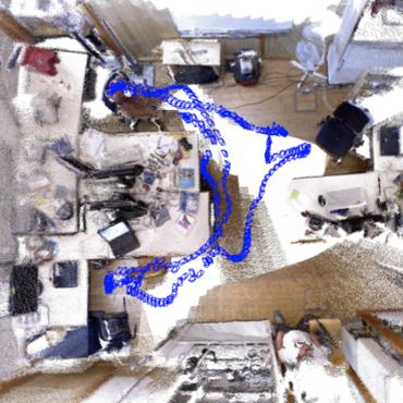
HI-SLAM: Monocular Real-time Dense Mapping with Hybrid Implicit Fields
For global consistency, we propose an efficient Sim(3)-based pose graph bundle adjustment (PGBA) approach to run online loop closing and mitigate the pose and scale drift.
Vision-based Large-scale 3D Semantic Mapping for Autonomous Driving Applications
In this paper, we present a complete pipeline for 3D semantic mapping solely based on a stereo camera system.

Distributed adaptive algorithm based on the asymmetric cost of error functions
In this paper, a family of novel diffusion adaptive estimation algorithm is proposed from the asymmetric cost function perspective by combining diffusion strategy and the linear-linear cost (LLC), quadratic-quadratic cost (QQC), and linear-exponential cost (LEC), at all distributed network nodes, and named diffusion LLCLMS (DLLCLMS), diffusion QQCLMS (DQQCLMS), and diffusion LECLMS (DLECLMS), respectively.
4Seasons: A Cross-Season Dataset for Multi-Weather SLAM in Autonomous Driving
We present a novel dataset covering seasonal and challenging perceptual conditions for autonomous driving.
Deep learning based cloud detection for medium and high resolution remote sensing images of different sensors
In this paper, we propose a deep learning based cloud detection method named multi-scale convolutional feature fusion (MSCFF) for remote sensing images of different sensors.
Correction of "Cloud Removal By Fusing Multi-Source and Multi-Temporal Images"
Remote sensing images often suffer from cloud cover.

A Spatial and Temporal Non-Local Filter Based Data Fusion
The spatiotemporal data fusion technique is considered as a cost-effective way to obtain remote sensing data with both high spatial resolution and high temporal frequency, by blending observations from multiple sensors with different advantages or characteristics.
